


Tropical storm warnings and storm surge warnings were issued in North Carolina and have extended north to the Virginia border as Hurricane Erin is expected to bring “life-threatening” surf and rip currents along much of the East Coast this week, forecasters say.
According to the National Hurricane Center, the rough surf conditions from the Category 2 storm could affect the Bahamas, Bermuda and beaches up and down the East Coast over the next several days. “Beachgoers are cautioned against swimming at most U.S. East Coast beaches due to life-threatening surf and rip currents,” the hurricane center said.
Officials in North Carolina have already declared a state of emergency in Dare County and ordered a mandatory evacuation of Hatteras Island, where tropical storm conditions and the possibility of life-threatening inundation of water from Erin are expected to have an impact on the barrier islands.
Erin formed in the eastern Atlantic Ocean last week, officially reaching hurricane status on Friday. It is the first hurricane of the 2025 Atlantic season.
Where is Hurricane Erin now, and what is its path?
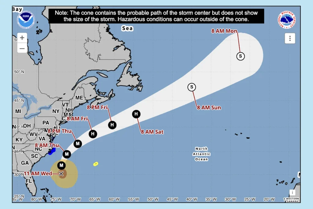
As of 11 a.m. ET Wednesday:
- Erin was located 545 miles west-southwest of Bermuda and about 365 miles south-southeast of Cape Hatteras, N.C.
- The storm has maximum sustained winds of 110 mph, making it a Category 2 storm.
- It is moving north at 13 mph.
According to the NHC’s latest advisory, Erin is expected to turn toward the north-northeast later today and tonight. It’s expected to pick up speed toward the northeast and east-northeast by Thursday and Friday.
The computer models show that the center of the storm will move over the western Atlantic between the U.S. East Coast and Bermuda today through early Friday and then pass south of Atlantic Canada by the weekend.
Watches and warnings
As of 11 a.m. ET Wednesday, these are the advisories in place, according to the NHC:
Tropical storm warnings are in effect for:
- Beaufort Inlet, N.C., to Chincoteague, Va., including Pamlico and Albemarle sounds.
Tropical storm watches are in effect for:
- Bermuda
A storm surge warning is in effect for:
- Cape Lookout to Duck, N.C.
What those watches and warnings mean
A storm surge warning means there is a danger of life-threatening inundation, from rising water moving inland from the coastline, over the next 36 hours in the indicated locations. In North Carolina, 2 to 4 feet of storm surge is possible from Cape Lookout to Duck. And up to 3 feet of storm surge is possible from South Santee River, S.C., to Cape May, N.J.
Tropical storm conditions are expected in portions of the Outer Banks and Virginia coastline starting late today. On the mid-Atlantic and southern New England coast, wind gusts to tropical storm force are forecast Thursday through early Friday. Additionally, Bermuda could see tropical storm conditions on Thursday and Friday.
Heavy rainfall is possible on the Outer Banks this afternoon into Thursday, with the potential for 1 to 2 inches.
Though Erin is not expected to make direct landfall, swells generated by the storm will affect the Bahamas, Bermuda, the East Coast of the United States and Atlantic Canada during the next several days.
“These rough ocean conditions are expected to cause life-threatening surf and rip currents,” the NHC said.
What are the chances Erin will intensify?
Hurricanes are rated on the Saffir-Simpson Hurricane Wind Scale, ranging from Category 1 to Category 5, with 5 being the most severe. A storm is considered a major hurricane when it reaches Category 3 strength, with sustained winds of at least 111 mph.
Erin reached Category 4 strength on Saturday and again on Monday before weakening on Tuesday. It is currently a Category 2 storm, with maximum sustained winds of 110 mph.
“Some strengthening is possible during the next day or so,” the NHC said. “Weakening is likely to begin by Friday, but Erin is forecast to remain a hurricane into the weekend.”
Hurricane-force winds extend outward up to 80 miles from its center, and tropical-storm-force winds extend outward up to 230 miles.
How is hurricane season shaping up?
The 2025 Atlantic hurricane season, which began June 1 and runs through the end of November, has a 50% chance of being above normal.
Earlier this month, forecasters at the National Oceanic and Atmospheric Administration slightly updated the number of expected storms to 13 to 18 (estimated at 13 to 19 in May), of which up to five could become major hurricanes (with winds of more than 111 mph).
A typical hurricane season averages 14 named storms. We’re currently about halfway through this year’s Atlantic hurricane season, and as of Aug. 15, there have been five so far: tropical storms Andrea, Barry, Chantal and Dexter, and now Hurricane Erin.