





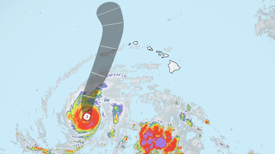
Tropical storm warnings are in effect for the Hawaiian islands of Kauai and Niihau as powerful Hurricane Lowell takes aim at the state. It’s the third storm in just over three weeks to target Hawaii, as El Niño supercharges the Pacific hurricane season.
Tropical-storm-force winds of over 39 mph are expected late Monday into Tuesday local time but will be confined to the western islands. Mountain peaks and slopes could see gusts reaching hurricane force, as the islands’ terrain accelerates the winds.
☀️ Get your local forecast from the CNN Weather app
Lowell is a Category 3 hurricane with winds of 120 mph, traveling north at 6 mph, according to the National Hurricane Center. It has fluctuated between categories as it undergoes the normal cycling of a major hurricane.
The storm is forecast to be near Category 2 strength when it makes its closest approach to Hawaii. Lowell’s center is expected to pass about 100 miles west of Niihau, or 150 miles west of Kauai, from later Monday night through Tuesday morning, according to the hurricane center.
That distance keeps the worst of the hurricane’s winds offshore, but Hawaii will still feel Lowell’s effects through dangerous surf and heavy rain.
Over the past several days, Lowell has been trapped underneath a weak upper-level area of high pressure, which has acted as a force field for Hawaii, forcing the storm to keep traveling west and stay south of the islands.
But the high-pressure system weakened this weekend as a trough of cold air dove in from the north Pacific and interacted with a nearby area of low pressure. Freed from the high pressure’s influence, Lowell is making a dramatic right turn — swinging north to scrape by Hawaii’s western islands.
The setup bears a resemblance to 1992’s Hurricane Iniki, which came ashore on Kauai as a Category 4 hurricane and remains Hawaii’s worst storm on record. But this time, Lowell is forecast to stay far enough offshore to avoid a direct hit.
Hawaii Gov. Josh Green declared a state of emergency for the entire state to free up resources and activate Hawaii National Guard units. Six high-water vehicles are also being deployed to Kauai, he said.
Swells from Lowell are already producing hazardous surf across the state, and conditions are expected to become much more dangerous Monday. A high surf warning is in effect through early Tuesday for south-facing shores of Oahu, Maui County and the Big Island. Surf of 7 to 10 feet will rapidly build Monday afternoon and evening, reaching 12 to 20 feet on Oahu and 12 to 16 feet across Maui County and the Big Island, according to the National Weather Service in Honolulu.
The waves could sweep across beaches and low-lying coastal areas, threatening roads and other infrastructure. Powerful rip currents and large breaking waves could also create dangerous conditions at beaches and harbor entrances, warned the weather service.
Heavy rain will threaten the entire state. Lowell is forecast to drop 6 to 10 inches of rain on Kauai, and Niihau, with isolated totals over 14 inches possible. On the Big Island, 4 to 8 inches are expected, with isolated rainfall totals up to one foot. Lower amounts of 2 to 4 inches are forecast for Oahu, Molokai, Lanai and Maui, but those islands could see up to 8 inches in the mountainous areas.
The National Hurricane Center has warned of “significant flash flooding and mudslides,” especially in steep terrain.
El Niño is helping fuel increased storm potential in the central Pacific this year, warming ocean temperatures in the region and weakening storm-killing upper-level winds, on top of an ocean already warming from climate change.
The National Oceanic and Atmospheric Administration has forecast an above-average central Pacific season, with five to 13 cyclones expected.
For more CNN news and newsletters create an account at CNN.com